|
GEOPORTAL


|

|
CADASTRAL NODE
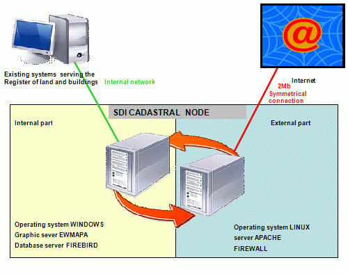
A cadastral node is a set of servers providing specific services, it is composed of two parts:
- internal one, not visible in the Internet,
- external one, which has access to the internal network on the one side, and to public network on the other side.

A cadastral node may be located in the district/county and municipality, which has been entrusted with maintaining the resource, in accordance with item 4 art. 6a of the Geodetic and Cartographic Law.
A cadastral node provides both public and non-public (protected services. Only the WMS(1) service is publicly provided. The remaining services are provided via the Provincial (Voivodship) Server Proxy (WSP), which has the task of controlling access rights. Such a solution significantly simplifies the problem of access protection to data at county /district level.
Services have been divided into basic and additional ones.
Basic services are:
- WMS service with public content: plots, plot numbers, buildings, street axes, street names, address points (possibly additionally also the areas of spatial development plan and their markings, the sketch of the spatial development plan in line with the study published at www.gugik.gov.pl entitled: „The Distribution of geometric large scale data based upon WMS and WFS servers“ prepared by the team of the National Spatial Data Infrastructure).
As minimum being subject of implementation, the service of making plot and plot numbers available has been assumed.
On the scheme that service is labelled WMS(1).
It is a publicly available service, in compliance with the format determined in the project.
As address databases or spatial development plans are prepared in municipalities, it is also permitted to make layers available from the level of municipality (on the scheme that service has been labelled WMS(1a)).
It should be stressed that public WMS data will constitute 95 of the entire traffic in the network, generated by a cadastral node, that is why their direct distribution is so important.
- WFS service is a service with protected content, pertaining to geometry and identification data of the register of land and buildings. In the scheme that service is marked as WFS(1). That service is available only for the Provincial (Voivodship) Server Proxy (WSP) and is provided only in the encoded connection https. In the basic version (implemented) the service is used for search for plots and adjusted to address search.
The set of services enables creating a portal which presents, among other things, the following borders of plots, buildings, street axes, addresses. Additionally it enables searching for plots and addresses. Because of the way of data collection (WMS), it is possible to provide a continuous covering with register data of the entire territory of the country.
The presented data of a district/county are supplemented with data from the national node, in particular the ortho-photomap.
Additional services are available exclusively for the Provincial (Voivodship) Server Proxy (WSP) and are provided in the encoded connection mode https, they are:
- WMS with non-public content: geodetic matrices. croplands, classification contours, utilities, basic map. On the scheme the service is labelled WMS(2).
- WFS with non-public content: geodetic matrices. croplands, classification contours, borders of precincts and register units, utilities, basic map. On the scheme the service is labelled WFS(2). The services WFS(1) and WFS(2) may be provided by the same server.
- OSN service (geodetic matrices) is a special service enabling downloading of information about geodetic matrices, mainly of class three and survey class. On the scheme that service is labelled OSN(1).
- OPE service (geodetic surveys) is a special service enabling access to the database of surveys of the district/county geodetic and cartographic documentation centre.
- EGB service (register of land and buildings) is a special service enabling access to data in the descriptive part of the register of land and buildings.
Thanks to additional services, practically the entire content of the resource of district/county geodetic and cartographic documentation centre can be made available.
|